By Simone Grant for FSA Public Affairs
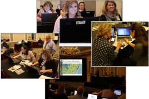
 In mid-March, Geographic Information System specialists, county office employees, national office staff, and program management of all levels at the U.S. Department of Agriculture (USDA) Farm Service Agency (FSA) gathered together in Charlotte, North Carolina, for FSA’s first national face-to-face GIS training in more than 10 years.
This training was held in order to achieve the following goals:
- Identify key GIS position responsibilities and skills needed for the completion of key GIS tasks for all FSA employees serving as State GIS Specialists or acting as GIS resources;
- Address previously identified training needs to help those in GIS positions achieve a standardized approach to national program delivery;
- Define common dataset, reports and tools recommended for completion of GIS tasks.
In order to accomplish this feat, a GIS Training Tiger Team was established comprised of Washington, D.C., National Office Staff, State GIS Specialists from around the nation, and representatives from the FSA Aerial Photography Field Office (APFO) in Salt Lake City, Utah. This team, led by Production, Emergencies and Compliance Division’s Common Provisions Section Head, Todd Anderson, and GIS Program Manager, Shirley Hall, compiled all training materials, including user guides, Power Point presentations, hands-on exercises complete with datasets, skits, and GIS demonstrations for the twenty different courses that would be held throughout the week, including Geospatial Metadata, Cartographic Design and Mapping, Imagery, Special Projects and Processes, Professional Development, CRM Farm Records, GIS Data Integrity (to name a few).
All this material was prepared through long hours, countless virtual and in-person work sessions, and an incredible amount of juggling normal daily responsibilities over the course of three and a half months.
The result of all their efforts? The training was a huge success. Said some of the training attendees:
“It was really nice to be working with data for our home states but still following along with a group project.” (Pennsylvania)

FSA GIS Training Tiger Team (Top to Bottom) Alex Dubish (MT), Steve Stark (National Office), Alison Lenz (National Office), Ryan Hunt (AZ) Dan Mertz (VA), Kent Willett (OR), Dan Janes (ND) Sarah AcMoody (MI), Heather Grady (NY), David Davis (APFO, Salt Lake City) Billie Jo Smith (NE), Alanda Crawford (National Office), Zachary Adkins (APFO, Salt Lake City) David Taylor (National Office), Simone Grant (National Office Support), Brenda Zachman (WI) Shirley Hall (National Office), Jeff Bloomquist (MN), Todd Anderson (National Office)
“The hands on exercises were the best and I loved that the training team was there to assist when I fell behind… I love the user guides provided. They are easy to follow and a good reference for when I start implementing these procedures in my state.” (Louisiana)
Said one APFO representative about the training team, “I knew that there are a lot a very good people in the national, state, and county offices, but was amazed when seeing them in action at this training. The level of expertise, teaching ability, dedication, enthusiasm, and passion for their work was amazing… It’s incredible that they were able to… work all week with such enthusiasm.”
“I was impressed by the enthusiasm and capability of the GIS team …assembled in Charlotte. They displayed many maps that showed the variety of work FSA does in imaginative ways. I would like to create more visibility for the work they do” (Deputy Administrator of Farm Programs)
Our next “Mapping the Ag-Nation” article will feature an interview of the National GIS Training Tiger Team to provide a more in-depth look at what it took to bring this training to fruition. To learn more about FSA’s geographic information systems and aerial photography capabilities, click here.
Questions? Comments? Contact Shirley Hall, GIS Program Manager


One Response to Mapping the Ag-Nation: 2016 National GIS Training (Part 1)